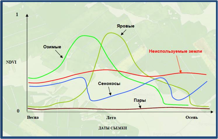
1.1 Monitoring of the state of agricultural land use
Monitoring land use efficiency of Kazakhstan territory, which has an area of about 3 Mil km,2 is a complicated task. For the northern agricultural territories, we have applied and combined Remote Sensing technologies with field work investigations for calibration and verification purposes. On the basis of satellite images the following groups of lands were identified: used, unused, hayfields and fallow.
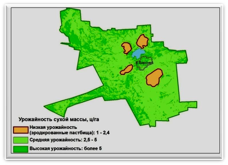
1.2 Determination of degradation areas of pasture
Vast territories of Northern, Western and Central Kazakhstan are used as natural pastures. Grazing is one of the oldest and most stable (regular) forms of human impact on the ecosystems of this territory. Violation of grazing norms and lack of grazing system has a negative impact on all components of the landscape. On the basis of remote sensing and ground calibration data, 3 classes of land productivity were determined. First grade ("high yield") includes not grazed and not downed pastures. This means practically no degradation, or it is very weak. In the second class ("average yield") subspecie pastures, degradation of the weak. The third class ("low yield") entered much down, very much shot down and scalped the pasture.
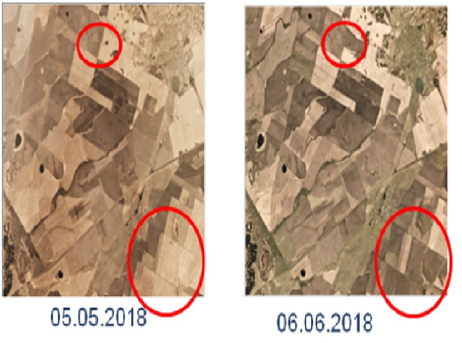
1.3 Monitoring of sowing and harvesting campaigns
Remote sensing allows to receive highly operational and reliable information about the state of crops. With the help of satellite systems Terra, Spot, Landsat, PlaneScope the sowing and harvesting works of crops were monitored.
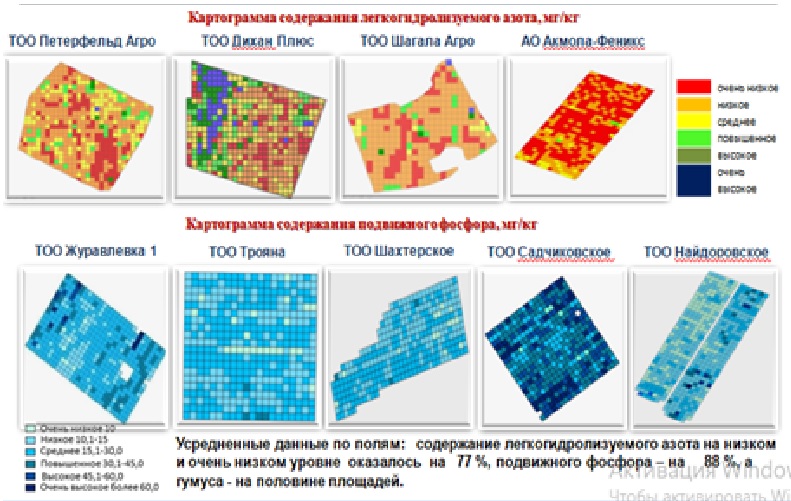
1.4 Implementation of precision agriculture technologies
Non-uniformity within the field and from field to field directly affect on overall productivity. On the basis of agrochemical analysis and electronic maps, differentiated fertilization was applied, for each section of the field on the basis of 1 ha grid. The technologies of precise geolocation, geographical information systems, space monitoring were implemented.
1.5 Satellite Enhanced Snowmelt Flood and Drought Predictions for the Kabul River Basin (KRB) with surface and groundwater modeling with specialists from Nazarbayev University.
Applying remote sensing satellite data, the modeling of the predicted impacts of climate change on runoff, snowmelt and vegetation cover was carried out.
1.6 Adaptation of the Combined Deficit Index (CDI) to assess agricultural drought in Kostanay region using remote sensing data
Agricultural drought occurs when the yield is below normal due to a prolonged shortage of moisture in the soil in the root zone caused by a shortage of precipitation compared to the normal period. This indicates that the agricultural drought has a scale of more than one month. In addition, it is clear that NDVI does not react immediately after rain. Therefore, the time delay of agricultural drought from meteorological is approximately 1 month in arid and semi-arid areas.
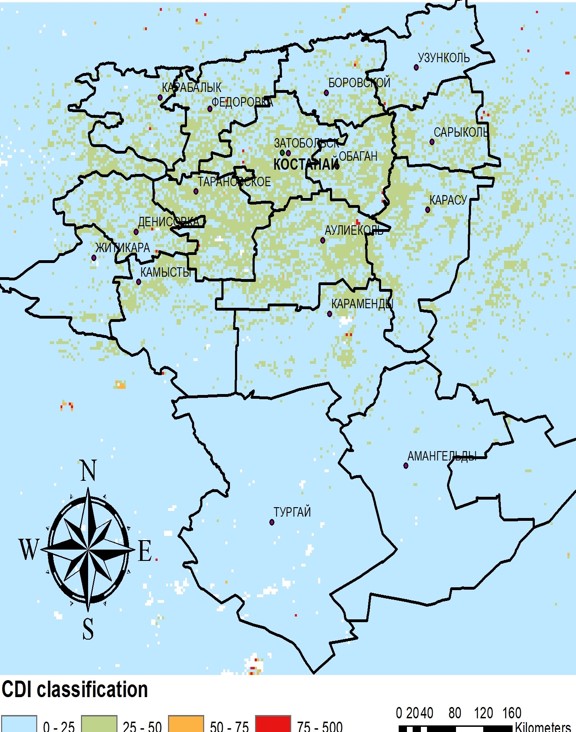
Map of the most drought-prone territories in Kostanay region over a 20-year period based on CDI
(<25 - normal; 25-50 - moderate drought, 50-75 - severe drought; >75 - extreme drought)
1.7 MONITORING OF WATER CONSUMPTION FOR IRRIGATION NEEDS
In July 2018, the Asian Development Bank (ADB) approved pilot demonstration activities under the RETA 6498 Water Finance Partnership Mechanism: Knowledge and Innovation Support under the ADB Water Finance Program to gain knowledge and strengthen the capacity of the Ministry of Agriculture of the Republic of Kazakhstan.
As part of the pilot project, ADB, together with specialists from S.Seifullin KATU, prepared images and analysis of data from drones obtained in cooperation with the IrriWatch platform (the Netherlands), which provided sensing technology and methodological support for the project. The demonstrated technologies and data reduce water consumption for irrigation needs and increase water productivity. The introduction of this technology and services throughout the country will increase the efficiency of water use.
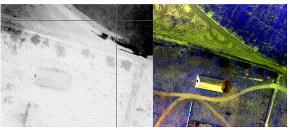
Thermal imaging with UAV in order to provide recommendations for irrigation of agricultural land based on soil moisture data (root zone)
1.8 MODELING OF ECOLOGICAL NICHES FOR NON - GREEDY LOCUSTS
The use of remote sensing methods and GIS technologies in monitoring locusts is associated with the detection of territories with favorable environmental conditions for reproduction. The definition of these conditions is the basis for the development of a model of the ecological niche of pests. An ecological niche is a set of all environmental factors within which the existence of a species in nature is possible.
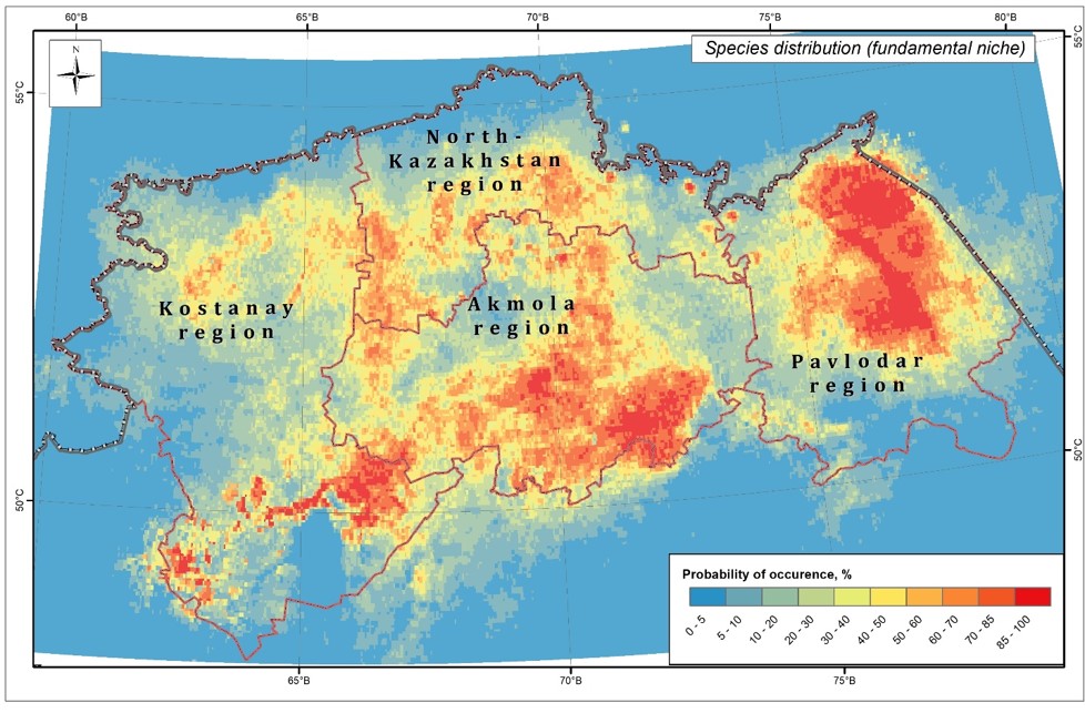
Area of settlement of non-invasive locust pests
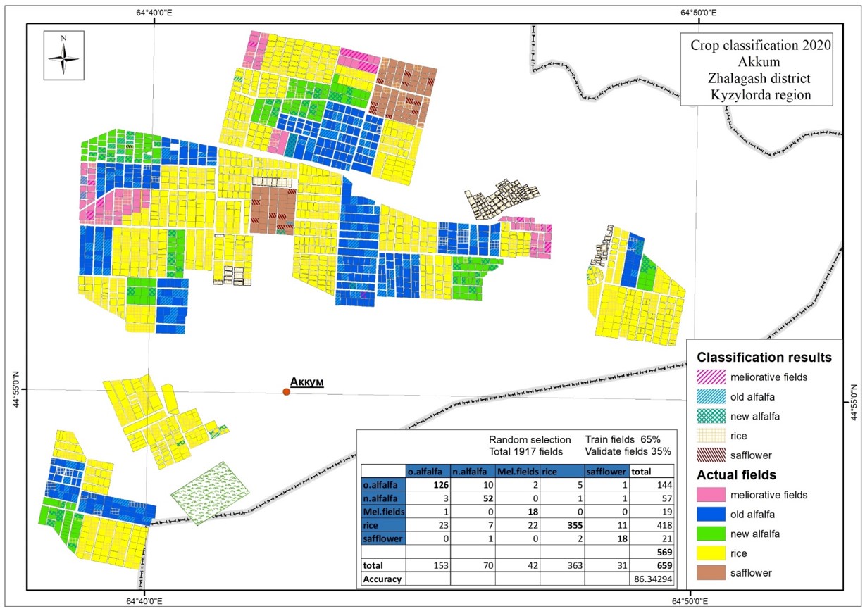
1.9 Identification of types of agricultural crops according to remote sensing data
Digitalization of agriculture for rational and effective management is an important priority for the development of the industry. The geographical location and distribution of agricultural crops is a valuable source of information for decision-making at the national and regional levels. Separate work on the classification of lands and major agricultural crops according to remote sensing data in the pilot territories has been carried out by KATU, the results of which demonstrate relatively high accuracy.
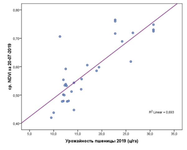
1.10 Predicting the yield of grain crops
The task of crop yield modeling forms the basis of current research in the field of precision agriculture and planning of the agro-industrial complex, regulation of agricultural markets, import and export operations. The most potential direction of research is related to the use of remote sensing data of the Earth. Yield forecasting is performed based on a series of multi-time images during the growing season, information about the growing crops of the current and past years, the actual last year's harvest for each field. The conducted studies have demonstrated that the vegetation indices of remote sensing show a strong correlation with yield.
Почетный профессор Казахского национального аграрного университета. Карьера. 1979 г. — Кайрат Айтуганов начал работать оператором цеха перевозки Кокчетавского почтамта. 1984-1985 гг. — ассистент кафедры почвоведения Целиноградского сельхозинститута. 1987-1989 гг. — агроном, старший агроном, главный экономист совхоза Карабулакский Зерендинского р-йона Кокчетавской обл.